Mutinda Lookout at 3,975 meters. The 4 day Rwenzori trek to Mutinda lookout allows a hike via Kilembe trail route to Mutinda Lookout (3,975m) in 4 days with magnificent views of Views of Mount Stanley & Mount Speke plus Giant Erica forest
Mutinda Lookout at 3,975 metres, is not the summit of any Rwenzori Mountains peak. Not a glaciated ridge requiring technical equipment. Simply a natural platform of ancient, moss-covered rock on the upper Kilembe Trekking Trail, from which — on a clear morning, with the cloud below you for once rather than above — the entirety of the Rwenzori Mountains’s upper massif is visible in a single panorama: Mount Stanley (5,109 m) with its Margherita, Alexandra, and Albert summits, Mount Speke (4,890 m), Mount Baker (4,843 m), and the glaciated ridgelines that define Africa’s third highest mountain range, laid out before you in a display that the word ‘extraordinary’ enters and immediately fails to adequately describe.
 The 4-Day Rwenzori Trek to Mutinda Lookout via the Kilembe Trail is the finest non-technical alpine experience available in Rwenzori Mountains National Park. In 4 days, the trail climbs from the Afro-montane forest at the mountain’s southern base through bamboo, Erica woodland, and open heath to the very threshold of the alpine zone — reaching 3,975 metres without glacier travel, without crampons, and without the compressed acclimatization demands of the summit programmes. It is a trek that moves through four distinct ecological zones, sleeps in two mountain camps of extraordinary character, and arrives at a viewpoint that, in the experience of Rwenzori trekking guides, produces more genuine silence and more genuine tears than any other point on the Kilembe Trail. Not from difficulty. From beauty.
What the four-day Rwenzori trek to Mutinda Lookout at 3,975m adds to shorter Kilembe Trail options is the full engagement with the journey’s highest section. The 3-Day Sine and Samalira Camp Trek reaches Samalira at approximately 3,150 metres — extraordinary in its own right. The four-day Mutinda lookout Rwenzori trek expedition pushes beyond, past Kalalama Camp at 3,147 metres without stopping, continuing to Mutinda Camp at 3,588 metres and then — on the afternoon of Day 2 or the morning of Day 3 — to the Mutinda Lookout at 3,975 metres: the highest point accessible on the Kilembe Trail’s non-technical Rwenzori trekking excursions and a position from which the entire Rwenzori massif declares itself without reservation. The fourth day is the descent — long, rewarding, rich with the particular pleasure of moving through all that extraordinary country in the opposite direction, with everything known and nothing urgent.
At Gorilla Safaris, this trek is arranged privately for every group: your own certified mountain guide, your own dedicated porter team, your own schedule across all four days. Whether you are an adventurous family with teenagers ready for their first genuine high-altitude challenge, a couple seeking a physical shared achievement in one of Africa’s most botanically surreal landscapes, a solo traveler who wants expert company and zero logistical burden, or a group of serious trekkers for whom the Mutinda Lookout panorama has been on the wish list for years — this is the Rwenzori trekking expedition that delivers it, arranged by people who have stood on those moss-covered rocks many times and whose knowledge of how to get you there safely and memorably is as detailed as any guide can make it.
The Rwenzori’s Most Accessible High Viewpoint
At 3,975 metres above sea level, the Mutinda Lookout is the highest point accessible on the Kilembe Trail without technical mountaineering equipment. It occupies a natural rock platform on the upper ridge of the Mutinda massif — a subsidiary ridge of the southern Rwenzori accessible from Mutinda Camp in one to two hours of ascent — from which, on the clearest mornings, a 360-degree panorama reveals the full extent of the Rwenzori’s upper mountain world. To the north and east, the great massifs of the Central Circuit — Stanley, Speke, Baker — are visible above the cloud systems that typically fill the Bujuku Valley. To the south and west, the Kilembe Trail corridor drops away through forested ridgelines toward the copper-belt foothills and the Kasese plains, the DRC border visible on the western horizon in exceptional conditions. The Lookout’s position — high enough to see above the mountain’s daily cloud cycle on the best mornings, low enough to be reached without technical equipment in two hours from the camp — makes it the most accessible high viewpoint on any Rwenzori short trekking expeditions.
Mutinda Camp — A Camp of Extraordinary Character
Mutinda Camp sits at 3,588 metres above sea level on the upper Kilembe Trail, set near a small river and a cascade that provides the camp’s soundtrack through the night and the soundtrack for the morning’s return from the Lookout. The camp is positioned in the upper Erica forest — the zone where the giant Erica trees reach their most extraordinary dimensions and their most sculptural forms, their trunks buried beneath cushions of sphagnum moss and their branches draped in old man’s beard lichen that moves in the gentlest air. The elevation at Mutinda produces a quality of silence and a quality of cold that the lower camps cannot replicate: the nights are properly mountain nights, requiring every layer in the pack, and the mornings — when the cloud below the camp lifts before the cloud above it builds — are among the finest that the Kilembe Trail offers in any season.
Kalalama Camp — The Gateway to the Upper Trail
Between Sine Camp and Mutinda Camp, the trail passes through Kalalama Camp at 3,147 metres — a rest point and emergency camp in the Heather-Rapanea zone that marks the trail’s entry into genuinely upper-mountain terrain. Kalalama provides the first clear views of the day over the Kilembe Valley below and, on clear mornings, toward the higher ridge lines above. The terrain around Kalalama represents the transition from the dense enclosed Erica forest of the mid-altitude zone to the more open heath and bog of the trail above — the first section where the sky becomes a dominant element of the landscape rather than a series of gaps in the canopy. The camp is used as a brief rest and tea stop on the Day 2 ascent rather than an overnight point, though it can accommodate groups in emergency conditions.
The Six Rwenzori Massifs — What You See from Mutinda Lookout
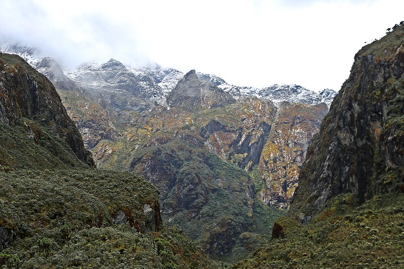
The panorama from Mutinda Lookout on a clear morning is the finest available on any Kilembe Trail short trekking expedition. The range’s six major massifs are arranged around the upper trail in a configuration that the lookout’s elevated and exposed position reveals more completely than any other non-technical viewpoint. Mount Stanley (5,109 m)—carrying the Margherita, Alexandra, and Albert peaks above the Elena and Coronation glaciers—dominates the northern view. Mount Speke (4,890 m) with Vittorio Emanuele Peak, Mount Baker (4,843 m) with Edward Peak, Mount Emin (4,798 m), Mount Gessi (4,715 m), and Mount Luigi di Savoia (4,627 m) are variously visible depending on cloud conditions. To the south, the Portal Peaks (Kihuma, 4,391 m) frame the Kilembe Trail corridor. The Lookout also commands views across the DRC border to the west and, in exceptional conditions, the faint outline of the Virunga Volcanoes on the southwestern horizon.
Getting to the Kilembe Trailhead — Rwenzori Mountains National Park
From Kampala or Entebbe
The Kilembe Trail begins at the Kyanjuki Trekkers Hostel and the associated UWA rangers post at 1,727 meters, approximately 12 kilometers south of Kasese town on the Kilembe road. Kasese itself lies approximately 370 kilometers west of Kampala on the main western highway—a drive of five to six hours through the highlands of southwestern Uganda and the rift valley escarpment. Your dedicated Gorilla Safaris vehicle handles the full transfer from your Kampala hotel or Entebbe airport, with a planned comfort stop and refreshments en route. Most guests overnight in Kasese or Kilembe the night before Day 1, giving the early trailhead start a relaxed rather than road-worn quality.
By Domestic Flight to Kasese
Uganda Airlines operates domestic flights from Entebbe International Airport to Kasese Aerodrome, reducing the transfer time to under an hour in the air. Your dedicated vehicle meets the flight at Kasese and completes the 12-kilometre transfer to the Kilembe trailhead. For guests arriving from Rwanda after a gorilla trekking safari in Volcanoes National Park or from Entebbe after a Bwindi gorilla trekking experience, the domestic flight option preserves the maximum number of trekking days by eliminating the road transfer from the equation entirely.
4-Day Mutinda Lookout Trek — Itinerary at a Glance
Four days on the Kilembe Trail’s finest route.
- Day 1 — Kilembe Trailhead to Sine Camp: Transfer from Kasese to Kilembe | UWA briefing at Kyanjuki rangers post | Trek through Afro-montane forest | Blue monkeys, colobus, and L’Hoest’s monkey | Rwenzori Turaco and endemic birds | Enock’s Falls | Overnight at Sine Camp (2,596 m)
- Day 2 — Sine Camp to Mutinda Camp via Kalalama: Bamboo-Mimulopsis zone ascent | Kalalama Camp rest stop (3,147 m) | Mossy river valley | Giant Erica trees | Afternoon optional Lookout ascent | Overnight at Mutinda Camp (3,588 m)
- Day 3 — Mutinda Lookout Summit and Exploration Day: Dawn ascent to Mutinda Lookout (3,975 m) | Panoramic views of Stanley, Speke, Baker and the Rwenzori massifs | Morning exploration of upper Erica zone | Giant Senecio and Lobelia | Afternoon at Mutinda Camp | Second overnight at Mutinda Camp
- Day 4 — Mutinda Camp — Full Descent to Kilembe Trailhead: Return descent via Kalalama, bamboo zone and lower montane forest | Enock’s Falls revisited | Return to Kyanjuki trailhead | Trekking certificate | Onward transfer to Kasese
Total Elevation Gain: Approximately 2,248 m from Kyanjuki (1,727 m) to Mutinda Lookout (3,975 m)
Total Distance: Approximately 38–44 km across all 4 days, including Mutinda Lookout ascent and full descent
Highest Point: Mutinda Lookout, 3,975 m above sea level
Difficulty: Moderate to challenging — suitable for fit adults and active teenagers aged 14+; no technical equipment required
Trek Style: Fully private, guide-led, porter-supported—your pace, your programme, your mountain
Day 1 — The Southern Forest: Kilembe to Sine Camp (2,596 m)
The Briefing at Kyanjuki
The Kilembe Trail begins at the Kyanjuki Trekkers Hostel and UWA rangers post at 1,727 meters—a point approximately 12 kilometers south of Kasese town, where the cultivated foothills of the copper belt give way definitively to the park boundary and the protected forest above. Your private guide meets the group at the rangers’ post for the permit check and trail briefing—a formality that your Gorilla Safaris team has prepared for in advance, with permits confirmed and fees paid before arrival, so the briefing is what it should be: an orientation to the three days ahead rather than an administrative exercise. The ranger escort for the full four days is assigned. The route is explained—Day 1 to Sine Camp, Day 2 to Mutinda, and the Lookout on Day 3—and then the forest begins.
The Afro-Montane Forest—The Kilembe Trail’s Opening Chapter
The first section of the Kilembe Trail ascends through what botanists classify as Afro-montane forest—the Rwenzori’s version of the tropical montane forest that covers mountain slopes throughout the Albertine Rift, but here at a density and biological complexity that justifies the Rwenzori’s UNESCO designation on ecological grounds alone. The canopy closes overhead within the first hundred meters. The temperature drops. The soil underfoot softens from the red laterite of the foothills to the rich, dark organic material of a forest floor that has been building for thousands of years without interruption. Tall forest trees—Podocarpus, Symphonia, and Macaranga—rise around the trail, their trunks colonized by orchids and ferns at every level from ground to crown.
Blue monkeys—Cercopithecus mitis—appear in the canopy within the first half-hour with the reliable composure of animals accustomed to occasional human passage and entirely comfortable with it. Black-and-white colobus monkeys move through the upper canopy in groups of fifteen to twenty—their acrobatic passage through the branches generating a volume of noise entirely disproportionate to their elegance and providing, when the group pauses to watch, one of the most spectacular primate displays available on any Rwenzori trekking program. The L’Hoest’s monkey—rarer, shyer, and of deep cultural significance to the Bakonzo people, whose Omusinga (traditional king) considers it under royal protection—is occasionally encountered in the deeper forest sections. Your guide knows the trail sections where L’Hoest’s is most reliably found and the slow, patient pause that produces the sighting.
The Rwenzori Turaco is heard before it is seen — its deep, resonant croaking carrying through the forest well ahead of the bird itself. When it moves through a gap in the canopy, the crimson flash of its wing panel against the green produces the particular kind of arrested attention that genuinely vivid color in a natural context always generates: the mind refuses it briefly, as if the colour is too saturated to be real, and then accepts it and registers that the Rwenzori is simply operating by different color rules than the rest of the world. Your guide identifies bird calls throughout the ascent with the ease of someone for whom the Kilembe Trail’s avifauna is a known and comfortable landscape—one more layer of the mountain’s biography that they carry with them on every programme.
Enock’s Falls — Two Hundred Metres from Sine Camp
The trail ascends steadily through the middle section of the lower forest, crossing streams on log bridges and stepping stones, before arriving in the vicinity of Enock’s Falls — the cascade named for one of the Kilembe Trail’s founding local guides, whose knowledge of this terrain shaped the route that all subsequent trekkers have followed. At approximately 200 meters from Sine Camp, the falls are encountered as a sound before a sight: a deepening in the forest’s water voice, growing from the background murmur of small stream crossings to something fuller and more insistent. The pool below the main cascade is cold, clear, and enclosed by vegetation that frames the water in a way that seems choreographed. This is where most groups take the day’s main rest—food prepared by the camp cook team who have moved ahead to establish Sine Camp, the falls providing both backdrop and soundtrack.
The distance from Enock’s Falls to Sine Camp is short enough that the final approach carries a specific quality of anticipation — the forest thinning slightly, the vegetation beginning to show the character of the bamboo zone’s lower margin, and then the camp ridge appearing ahead. Sine Camp, at 2,596 meters, sits on a narrow ridge in the lower Erica forest, with views down the Kilembe Valley through gaps in the trees and the sound of a waterfall below — the same falls that Enock’s Falls cascades toward—audible from the hut’s outdoor sitting area on still evenings. The camp’s wooden huts, simple and purposeful, are the first indication that the mountain will provide two nights of genuinely removed, genuinely quiet accommodation. A campfire, if conditions permit, is the evening’s focus while the cook prepares dinner and the guide talks about tomorrow’s ascent to Mutinda.
Overnight: Sine Camp (2,596 m) — twin-share wooden mountain huts with sleeping mats and blankets. Hot dinner and full breakfast prepared by your dedicated camp cook. Views of the Kilembe Valley from the ridge clearing.
Day 2 — The High Forest: Sine Camp to Mutinda Camp (3,588 m)
Into the Bamboo — The Trail’s Most Physical Day
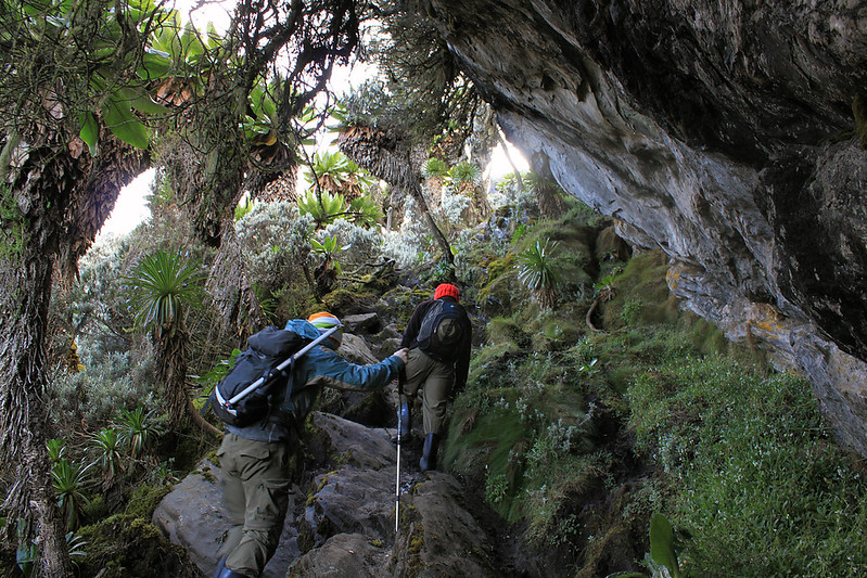
Day 2 is the four-day Rwenzori trek to Mutinda lookout, the most sustained physical challenge and the most botanically varied. The trail leaves Sine Camp and enters the bamboo-Mimulopsis zone immediately—a steep, high-stepped ascent through cane stands whose density creates an enclosed, rhythmic world of filtered light and hollow percussion. In dry conditions, the bamboo zone is demanding but straightforward. In wet conditions—which the Rwenzori produces reliably and frequently—the stepped trail surface becomes slippery in a way that tests the ankle stability of every boot on the program, and trekking poles earn their full value within the first twenty minutes of the bamboo ascent. The gradient eases as the bamboo thins at higher altitudes, but the cumulative elevation gain of approximately 550 meters from Sine Camp to the Kalalama rest point is a sustained effort that the guide manages by setting a pace calibrated to the group’s fitness and by identifying rest points at the stream crossings where the trail’s gradient briefly relents.
Kalalama Camp—Tea at 3,147 Metres
At Kalalama Camp, 3,147 meters, the bamboo zone , the bamboo zone yields definitively to the Heather-Rapanea zone—the way definitively to the Heather-Rapanea zone—the lower margin of the Erica heath that will define the remainder of the ascent. The camp, used as a brief rest stop on the four-day Rwenzori trek to Mutinda Lookout rather than an overnight, occupies a position with the first truly open views of the day: the Kilembe Valley corridor visible below and the upper ridgeline above beginning to show the architecture of the Erica zone’s ancient, lichen-draped trees. Your guide brews tea at the camp while the group rests—a proper pause, long enough to register the altitude’s effect (the air noticeably thinner, the effort of the ascent felt in the lungs in a way that sea-level exercise doesn’t produce) and to identify that the body is managing the acclimatization process with the composure that a gradual ascent profile encourages.
The Mossy River Valley — The Trail’s Most Beautiful Section
Above Kalalama, the trail enters what returning trekkers consistently describe as the Kilembe Trail’s most beautiful extended section: a deep valley carved by a mossy river that cascades over ancient rock under a canopy of giant Erica trees whose trunks are so thoroughly colonized by moss and lichen that the bark itself is invisible—buried under layers of cushioned green that give the whole valley a quality of padded softness, as if the forest has been upholstered from within. The trail meanders along this river valley—crossing it repeatedly on stepping stones, pausing at small cascade viewpoints, climbing over knolls, and dropping into the valley again in a rhythm that would be exhausting if the scenery were less extraordinary but is, in fact, completely absorbing.
The river sounds follow the trail continuously through this section—not the background murmur of small forest streams but the proper voice of a mountain river running fast over rocks, its volume varying with the grade of the valley and the amount of accumulated meltwater from the slopes above. The moss-covered waterfalls that the trail passes close to in several sections of the river valley are the Kilembe Trail’s least-photographed and most persistently beautiful feature: water over dark rock, entirely upholstered in living moss, the green of a saturation that afternoon photography cannot reliably capture and that morning photography, in the right light, produces images that look manufactured. They are not. They are simply the Rwenzori, doing what it has done in this specific valley for ten thousand years.
Arrival at Mutinda Camp
Mutinda Camp, at 3,588 meters, emerges from the upper section of the river valley climb with a completeness of setting that justifies every meter of the ascent: huts positioned near a small river and a cascade, the upper Erica forest pressed close on three sides, and the ridge that leads to the Mutinda Lookout visible above the camp on clear afternoons. At 3,588 meters, the cold arrives earlier and more thoroughly than at Sine Camp—layers come on as soon as movement stops, and the cook team’s hot drink is less a comfort than a genuine physiological requirement. The guide conducts the post-ascent acclimatization check with professional thoroughness: asking about headache, nausea, and appetite; assessing the group’s response to the altitude; and calibrating the Day 3 Lookout timing based on what the assessment reveals.
The afternoon, for those with energy after the day’s sustained ascent, offers the option of an early lookout reconnaissance—a ninety-minute to two-hour walk from the camp to the Mutinda Lookout at 3,975 meters in the afternoon light. The guide assesses this option based on the group’s condition and the afternoon’s cloud behavior. In clear conditions, the afternoon Lookout visit provides a first experience of the summit panorama before the full, timed morning visit on Day 3. In cloudy conditions, the afternoon rest at camp—watching the clouds build and shift around the peaks above, the river sound continuous, and the Erica trees in the last light—is entirely sufficient compensation. The cook produces the camp’s most substantial dinner of the program: the altitude and the effort of the ascent combine to create the kind of appetite that makes mountain cooking feel like fine dining regardless of the simplicity of the kitchen.
Overnight: Mutinda Camp (3,588 m) — twin-share mountain huts with sleeping mats and blankets. Hot dinner and full breakfast. Altitude monitoring by your private guide. Mountain river sounds throughout the night.
Day 3 — The Lookout and the Exploration: The Summit of the Journey
Dawn — The Pre-Sunrise Window
At 3,588 meters, the pre-dawn cold at Mutinda Camp is a serious thing. Temperatures regularly fall to 0°C and below before sunrise, and the wind that the Lookout Ridge channels has a quality that makes effective layering less a preference than a safety requirement. Your guide had tea ready before first light, and the summit party assembled at the camp’s upper edge as the sky began to show color. The decision on Lookout timing—whether to begin the ascent in darkness for a sunrise summit or to wait for first light and a clear-sky morning ascent—is made by the guide based on the previous evening’s cloud behavior and the current morning’s conditions. The Lookout rises approximately 387 meters above the camp over a trail of one to two hours, and the timing of arrival matters: the window between the overnight cloud clearing and the daily cloud cycle building from the Congo Basin system to the west is typically at its most generous in the first two hours after sunrise.
Mutinda Lookout—3,975 Meters Above Sea Level
The trail from Mutinda Camp to the Lookout ascends through the upper Erica forest before breaking onto open ridge terrain—the trees thinning, the sphagnum bog becoming the dominant ground cover, and the sky expanding overhead as the canopy retreats. Giant Senecio plants appear in the bog margins: those extraordinary succulent trees of the Rwenzori’s high altitudes, their rosettes of large leaves spiraling from thick central stems, their dead lower leaves providing the insulating skirt that allows them to survive the extreme temperature swings of the afro-alpine zone. Giant lobelia accompanies them in the wettest sections, its spike-leaved architecture rising from the bog cushions in a botanical display that belongs to no precedent in the experience of most trekkers encountering it for the first time.
The Mutinda Lookout itself is a natural platform of ancient, moss-covered rock at 3,975 meters—the highest point accessible without technical equipment on the Kilembe Trail. The platform is broad enough for a small group to stand at the edge and look in every direction simultaneously without crowding. And the view, on a clear morning, is one of those views the English language developed the word ‘panoramic’ to describe, but that word has become inadequate through overuse. The glaciated summits of Mount Stanley are visible to the north—Margherita, Alexandra, and Albert—where their permanent ice catches the morning light in blue-white fragments. Mount Speke to the northeast, Mount Baker, and the Freshfield Pass corridor to the east. Below the peaks, the great forested valleys of the Central Circuit and the Kilembe Trail corridor dropping away to the south. And to the west—on the best mornings—the Congo Basin, the DRC border, and the faint volcanic shapes of the Virunga range on the horizon.
The appropriate response to the Mutinda Lookout view on a clear morning is silence. Your guide, who has been here many times, understands this and provides it: standing a few meters back, available for questions but not initiating commentary, allowing the landscape to deliver its own information at whatever pace the person in front of it needs. The group stays as long as conditions allow — typically thirty minutes to an hour on clear mornings before the Congo Basin cloud system begins to rebuild from the west. Photographs are taken. Notes, mental or physical, are made. And then the descent begins.
The Exploration Morning — Above the Tree Line
The return from the Lookout to Mutinda Camp takes one to one and a half hours of descent. The morning that remains after this return—typically two to three hours before the midday rest period—is the program’s free exploration window: time at and above the camp in the upper Erica zone, with the giant Senecio plants now examined at leisure rather than passed in ascent-focused urgency; the endemic birdlife of the upper Kilembe zone engaged with patience rather than schedule, and the extraordinary botanical character of the Erica-Sphagnum zone given the unhurried attention it deserves.
The Strange Weaver — one of the most sought-after endemic species in the Albertine Rift—inhabits this upper zone and is regularly encountered on the morning walks above Mutinda Camp. The Rwenzori Hill Warbler, Chubb’s Cisticola, and the African Hill Babbler round out the upper trail’s distinctive endemic assemblage. For guests with binoculars and a serious birding interest, the morning above Mutinda after the Lookout return is one of the finest endemic birding opportunities on the Kilembe Trail—species density and habitat quality combining at an altitude that few short-trek expeditions on any African mountain reach.
The Afternoon and the Second Night at Mutinda
The afternoon of Day 3 at Mutinda Camp is the 4-day Rwenzori trekking to Mutinda Lookout’s quietest and, for many guests, its most deeply satisfying period. The Lookout has been reached. The panorama has been witnessed. The morning’s exploration has added botanical and avifaunal depth to the achievement of the ascent. What remains is the camp itself—the river sound, the Erica trees pressing close, and the cold arriving with the afternoon clouds—and whatever the group wants to make of it. Sleep, reading, conversation, and photography of the camp’s immediate surroundings in the particular light of the overcast afternoon—the 4 days Rwenzori trek to Mutinda lookout accommodates all of these with equal ease.
The second evening at Mutinda is the cook’s finest performance: the body at this altitude, after the Lookout ascent and the exploration morning, generates a genuine and demanding hunger that a hot, well-prepared mountain dinner satisfies in a way that no restaurant meal quite replicates. The guide’s end-of-day briefing covers the descent route and timing for Day 4—long, rewarding, requiring an early start to complete the full descent to the Kilembe trailhead before the afternoon cloud closes in on the lower forest sections. Early sleep follows naturally and is rarely resisted.
Second overnight: Mutinda Camp (3,588 m). Same accommodation as Night 2. Full dinner and breakfast included.
Day 4 — The Long Descent: Mutinda Camp to Kilembe Trailhead
Early Departure and the Upper Trail in Morning Light
Day 4 begins early—the descent from 3,588 meters to the Kilembe trailhead at 1,727 meters covers the full vertical range of the program in a single sustained day, and the guide’s preferred timing places the group on the trail before the daily cloud cycle begins building from the west. The Erica forest above Mutinda Camp, descended in the early morning light, has a quality that the ascent’s upward-focused attention missed entirely: the old man’s beard lichen on the Erica branches illuminated from the east; the mist rising from the river valley below, and the moss-covered waterfalls that were ascending companions on Day 2 now appearing from above—different angles, different light, different relationship.
Kalalama to Sine — Descending Through Botanical Worlds
The descent through the mossy river valley is the Day 4 of the trekking expedition’s most visually rewarding section—all of the extraordinary botanical detail that the ascent passed in physical effort is now revisited at the pace and attention of a group moving with gravity rather than against it. The moss-covered waterfalls, the Erica canopy, the stream crossings, the transition from the Heather-Rapanea zone through the bamboo zone and back into the lower Afro-montane forest—each transition is noticed and appreciated in the way that descents through previously ascended terrain allow: the known made new by direction and by what three days on the mountain has taught the observer to look for.
The bamboo zone on the descent is different from its ascent character: the steep high-stepped sections that were demanding coming up are now demanding in the opposite direction, placing significant load on the knees and making trekking poles essential for the sustained control they provide. The guide manages the descent pace with the same attention to group wellbeing that characterized the ascent—rest stops at the stream crossings, attention to footwear and pole technique on the slippery sections, encouragement where energy flags, and patience where the body needs a moment longer than the schedule prefers.
Enock’s Falls for the Last Time
Sine Camp is passed on the Day 4 descent—either as an overnight rest stop if the group’s pace requires it, or as a rest and lunch point before the final descent to the trailhead. Enock’s Falls, revisited for the last time on the approach to the camp, is encountered from above on the descent—the top of the cascade is visible from the trail, and the pool below is approached from a different angle than the ascent provided. Many groups spend longer here on the descent than the ascent: the objective is behind them, the trailhead is ahead, and the falls—unchanged, indifferent, beautiful in the particular way that a waterfall that has been falling for as long as anyone knows is always beautiful—provide the trek’s most natural farewell moment.
Return to Kilembe and onward.
The Kyanjuki ranger post appears in the mid-to-late afternoon, the forest opening to the cultivated margins of the park boundary, your dedicated vehicle exactly where it was confirmed to be. The park register is signed for the final time. UWA trekking certificates—issued to all guests completing a full Kilembe Trail program—are presented by your guide with the understated ceremony appropriate to a genuine achievement. And then Kasese: a hot shower, a proper bed, a meal at a table without altitude considerations, and the specific, deep satisfaction of four days well spent in one of the most extraordinary environments on the African continent.
The onward programme — whether Queen Elizabeth National Park for a game drive, Murchison Falls for a more extended wildlife extension, or Entebbe for onward flights — is arranged seamlessly by your Gorilla Safaris team, the vehicle and driver confirmed and ready before you reach the trailhead exit.
What the 4-Day Mutinda Lookout Trek Reveals
The Mutinda Lookout — Africa’s Most Accessible High Alpine Panorama
At 3,975 metres on the upper Kilembe Trail, the Mutinda Lookout provides a panoramic view of the Rwenzori’s full upper massif that no technical summit trekking expeditions is required to reach. The platform’s position above the daily cloud cycle’s typical upper boundary makes it the most reliably clear viewpoint on any Kilembe Trail trekking expedition, and its orientation—south-facing for the descent corridor and north-facing for the Mount Stanley and Speke massifs—makes it simultaneously a view of where you have come from and a view of what lies beyond the four-day Rwenzori trekking expedition reach. It is the Kilembe Trail’s finest moment and the primary reason the four-day version of the program exists in preference to shorter alternatives.
The Giant Erica Forest — Botanical Strangeness at Its Peak
The upper Kilembe Trail between Kalalama Camp and Mutinda Camp passes through what is, in the opinion of the Rwenzori’s most experienced botanical guides, the finest section of giant Erica forest accessible on any non-technical trail in the park. The trees here—Erica arborea and Erica johnstonii, growing to heights of eight to twelve meters—reach the most extraordinary dimensions available on the Kilembe Trail, their trunks buried beneath moss cushions of impossible depth and their branches draped in old man’s beard lichen that gives the whole forest a quality of slow, deliberate dreamwork. The sphagnum bog between the trees is equally extraordinary—a continuous carpet of living moss that springs and sinks beneath each step as if the forest floor itself is breathing. Walking through this zone for the first time is, for most trekkers, the moment that the Rwenzori stops being a mountain and becomes something that the ordinary vocabulary of outdoor experience cannot adequately contain.
The Mossy River Valley — Photography and Botanical Observation
The river valley section of the Day 2 ascent between Kalalama and Mutinda Camp is the Kilembe Trail’s most photographed single feature—a sustained section of trail along a mossy mountain river, past cascade viewpoints, under giant Erica canopy, through a botanical environment of such concentrated beauty that serious photographers routinely build dedicated stopping time into this section’s ascent and descent. The moss-covered waterfalls are a specific and frequently requested subject: water over ancient rock, entirely colonized by living moss, the green of a saturation that registers differently in every quality of light. The river’s sound is the section’s acoustic signature—constant, cold, carrying — and it is audible from the Mutinda Camp site throughout the program’s second and third nights.
Endemic Birdlife — From Forest Floor to Alpine Heath
The 4-Day Mutinda Lookout programme crosses three of the Kilembe Trail’s four avifaunal zones, each with its own endemic assemblage. In the lower Afro-montane forest: the Rwenzori Turaco, multiple forest sunbirds, the Rwenzori Horned Chameleon’s habitat zone, and the primate species of the Albertine Rift. Through the bamboo zone: the Rwenzori Apalis and transitional species of the bamboo-heather boundary. In the upper Erica zone around Mutinda Camp and the Lookout: the Strange Weaver, Rwenzori Hill Warbler, Chubb’s Cisticola, African Hill Babbler, and the Rwenzori Nightjar, whose churring call from the Erica scrub above the camp defines the Mutinda nights. The park records 217 bird species total, with over 70 Albertine Rift endemics. Your private guide functions as a trained naturalist for all four days.
Enock’s Falls — The Trail’s Most Beloved Waterfall
Encountered on the Day 1 ascent and the Day 4 descent, Enock’s Falls sit approximately 200 metres below Sine Camp on the lower Kilembe Trail — a multi-tiered cascade of clear, cold mountain water over dark rock in a clearing where the bamboo zone begins. Named for one of the Kilembe Trail’s founding Bakonzo guides, the falls are the trail’s most consistent landmark and its most consistently beautiful single feature. The pool below the main cascade provides cold water for feet and faces at the end of the Day 1 ascent and during the Day 4 descent—one of those small, physical pleasures of mountain trekking that the altitude and the effort make disproportionately satisfying.
Related Rwenzori Mountain Trekking Itineraries
The 4-Day Mutinda Lookout Trek sits at the upper end of the Kilembe Trail’s short-programme spectrum — the highest, longest, and most panoramically rewarding of the non-technical Kilembe Trail programmes. Understanding its relationship to adjacent programmes helps guests identify the version that best matches their time, ambition, and experience.
The 2-Day Rwenzori Trek to Sine Camp covers the trail’s lower section — forest, bamboo, and Enock’s Falls — for guests with limited time who want a genuine Kilembe Trail experience. The 3-Day Sine Camp Trek adds a full exploration day at Sine Camp. The 3-Day Sine and Samalira Camp Trek pushes to 3,150 meters for guests ready for a second ascent day without the full Mutinda commitment. On the Central Circuit, the 4-Day Central Circuit Trek to John Matte Hut offers an alternative four-day programme on the northern trail system, reaching 3,414 metres with views of the Stanley and Speke massifs from the Bujuku Valley. For guests ready for the full summit, the 4-Day Margherita Peak Trek is the fastest technical route to Africa’s third highest summit, and the 7-Day Central Circuit to Margherita Peak is the classic full-circuit program.
What to Pack for the 4-Day Mutinda Lookout Trek
Boots and Gaiters — Bamboo Zone Requirements
The Kilembe Trail to Mutinda Camp includes the bamboo zone ascent — the trail section that places the greatest demands on footwear of any section of the programme. The stepped bamboo trail is consistently wet and frequently slippery in the upper sections, and the transition from bamboo to Heather-Rapanea zone traverses some of the Kilembe Trail’s muddiest terrain in all conditions. Waterproof, ankle-supporting hiking boots thoroughly broken in before departure are the single most important item in the Mutinda packing list — more so than on the lower Kilembe trail Rwenzori trekking expeditions because the bamboo zone’s demands on ankle stability are significantly greater than anything in the lower forest. Gaiters are strongly recommended for the bamboo zone and above, keeping mud and debris from entering boot tops and significantly reducing the post-bamboo maintenance requirement. Gaiters are available for hire through Gorilla Safaris.
Layering for 2,248 Metres of Altitude Range
The 4-day Rwenzori trekking 2,248-meter altitude range — from the trailhead at 1,727 m to the Mutinda Lookout at 3,975 m—requires a layering system that functions across an effective temperature range of approximately 25°C from the warmest point on Day 1 to the coldest point on the pre-dawn Lookout ascent. The essential layers: a merino or synthetic moisture-wicking base layer, a mid-layer fleece, and a lightweight down jacket (rated to at least -5°C for the Mutinda Camp nights and the Lookout ascent). A waterproof hard-shell jacket with a sealed hood and waterproof trousers are non-negotiable from the bamboo zone upward. Insulated gloves, a balaclava, and a warm hat are required for the pre-dawn Lookout ascent and for the Mutinda Camp evenings, where temperatures regularly fall to 0°C or below. All base and mid-layers must be wool or synthetic—cotton loses its insulating value when wet and creates real cold risk at 3,500+ metres in damp conditions.
Trekking Poles — Essential on This Programme
Trekking poles are more important on the 4-Day Mutinda lookout rwenzori trekking expedition than on any other Kilembe Trail short trek. The bamboo zone ascent requires the stability that poles provide on steep, stepped, slippery terrain. The mossy river valley crossings on the mid-altitude sections benefit from the balance support that poles give on the stepping stone crossings. And the Day 4 descent from 3,588 metres — covering more than 1,800 metres of downhill terrain in a single day — makes poles a genuine knee-protection requirement. Poles are available for hire through Gorilla Safaris for guests not travelling with their own.
Sleeping Bag and Camp Essentials
The mountain hut accommodation at both Sine Camp and Mutinda Camp provides sleeping mats and blankets. A personal sleeping bag rated to -5°C or below is strongly recommended for the Mutinda Camp nights, where the combination of altitude, wind exposure, and consistent night-time temperatures below 5°C makes the hut’s blankets insufficient without personal sleeping insulation. A headtorch with multiple spare battery sets is essential — the pre-dawn Lookout departure in complete darkness makes a reliable torch non-optional. A camera with additional batteries or a charging bank (no mains electricity at either camp), 2–3 litres of water capacity, high-energy trail snacks, and a lightweight rain cover for the daypack complete the essential personal kit. A full gear list is provided at booking.
What’s Included in Your 4-Day Mutinda Lookout Trek
Your Gorilla Safaris Mutinda Lookout Trek is arranged as a completely private, fully supported mountain expedition. Every logistical element — from the permits secured in advance to the camp meals prepared at altitude — is confirmed before your arrival in Uganda.
- All Uganda Wildlife Authority (UWA) park entry fees and Kilembe Trail trekking permits for all 4 days
- Professional, UWA-certified private mountain guide for the full 4-day programme and Lookout ascent
- Dedicated UWA armed ranger escort throughout all 4 days on the trail
- Experienced porter team carrying all group camping equipment, food supplies, and shared loads
- All meals on the mountain: packed trail lunch Day 1, hot dinner Day 1, full breakfast and packed lunch Day 2, hot dinner Day 2, full breakfast Day 3 (Lookout day), hot dinner Day 3, full breakfast and packed descent lunch Day 4
- Drinking water and electrolyte supplements throughout all 4 days
- 2 nights mountain accommodation: Sine Camp (2,596 m) Night 1, Mutinda Camp (3,588 m) Nights 2 and 3 — twin-share wooden mountain huts with sleeping mats and blankets
- Basic first-aid kit and altitude monitoring; guide trained in altitude illness recognition and emergency response throughout
- UWA Kilembe Trail trekking certificate issued on completion
- Private vehicle transfers between Kasese and the Kilembe trailhead in both directions
- All government taxes and statutory levies
- Comprehensive pre-departure gear list, trail briefing, and altitude preparation guidance
What’s Not Included
For complete planning transparency, the following fall outside the trek package.
- International flights to Uganda (Entebbe International Airport)
- Uganda tourist visa — apply via the official online e-visa portal before travel
- Comprehensive travel and medical insurance including emergency mountain evacuation — mandatory for all trekking guests; policy must cover trekking above 3,500 m in Uganda
- Personal trekking equipment: waterproof boots, gaiters, trekking poles, waterproof jacket and trousers, layering system (full gear list provided at booking; selected items available for hire through Gorilla Safaris)
- Personal sleeping bag (rated to -5°C or below — strongly recommended for Mutinda Camp nights)
- Guide, porter, and cook gratuities — suggested amounts provided in pre-departure information
- Personal beverages beyond included drinking water
- Hotel or hostel accommodation in Kasese before and after the trek
- Any activities, transfers, or meals not described in this itinerary
- Personal expenditure and souvenirs
Best Time to Trek to Mutinda Lookout on the Kilembe Trail
June to August — The Prime Lookout Window
The long dry season from June through August offers the Kilembe Trail’s most reliable conditions for the Mutinda Lookout program. Trail surfaces are firmest (the bamboo zone’s stepped terrain at its most manageable), the Erica zone above Kalalama is navigable without significant mud difficulty, and — most importantly for the programme’s centerpiece experience—the probability of clear morning views from the Lookout toward the Stanley and Speke massifs is at its annual highest. June–August is Uganda’s peak travel season; Kilembe Trail permits and porter teams book in advance, and four-to-six months’ notice for departures in this period is strongly recommended.
December to February — Quieter and Equally Reliable
The short dry season from December through February provides conditions comparable to the peak season with significantly fewer trekkers on the trail. Permits are more readily available, the porter teams less stretched, and the Kilembe Trail atmosphere more intimate and solitary. The pre-dawn conditions at Mutinda Camp in this period are the coldest of the year—temperatures can fall below -5°C on the Lookout ridge—and the down jacket and gloves requirements become non-negotiable rather than strongly recommended. The Lookout views in the short dry season are, on the clearest mornings, the finest of the year: the air drier and the atmosphere clearer than in any other season.
March to May — The Long Rains and the Most Dramatic Bamboo
The long rains of March to May transform the Kilembe Trail in ways that experienced trekkers increasingly seek out deliberately. The bamboo zone in wet conditions is the most physically demanding and most atmospherically striking version of itself: the canes dripping, the trail stepping slippery, the enclosed world of filtered green-gold light at its most intense. The mossy river valley above Kalalama is at its most dramatic — the moss on every surface at its most saturated, the cascades running at full volume, the Erica zone shrouded in cloud that makes the whole landscape feel simultaneously enclosed and infinite. The Lookout views in the long rains are less reliable, the cloud more persistent and less predictable in its clearing windows. For trekkers who embrace the Rwenzori in its most atmospheric expression and prioritize botanical and birding richness over panoramic views, the long rains season is a genuine and deliberate choice.
September and October — Green Conditions and Family-Friendly Windows
September and October — the transition between Uganda’s long rains and the short dry season — offer the Kilembe Trail in its most accessible configuration for guests who are not veteran high-altitude trekkers. The vegetation is freshly green, the trail surfaces firming, and the temperature throughout the programme comfortable for guests whose fitness is good but whose altitude experience is limited. For families with school-age children whose October half-term creates the travel window, the September–October period is our most frequently recommended season for the Mutinda Lookout program, particularly for groups that include teenagers for whom the bamboo zone and the Lookout panorama represent a genuine introduction to high-altitude mountain travel. The gorilla trekking permit availability in Bwindi is also better in this period than in peak season, making the combined Bwindi–Mutinda itinerary both logistically and experientially compelling in the October window.
Frequently Asked Questions — 4 Days Rwenzori Trek to Mutinda Lookout
What is Mutinda Lookout and where is it on the Kilembe Trail?
Mutinda Lookout is a natural platform of ancient, moss-covered rock at 3,975 metres above sea level on the upper Kilembe Trail in Rwenzori Mountains National Park, Uganda. It is the highest point accessible on any non-technical programme on the Kilembe Trail and provides the finest panoramic view of the Rwenzori’s upper massifs—including Mount Stanley (5,109 m), Mount Speke (4,890 m), Mount Baker (4,843 m), and the Portal Peaks—available without glacier travel or technical mountaineering equipment. The Lookout is reached from Mutinda Camp (3,588 m) in one to two hours of ascent via the upper ridge trail. It is the Kilembe Trail’s signature viewpoint and the primary destination of the 4-Day Mutinda Lookout trekking programme.
How difficult is the 4-Day Rwenzori Trek to Mutinda Lookout?
The 4-Day Mutinda Lookout Trek is graded moderate to challenging. The most demanding day is Day 2 — the ascent from Sine Camp (2,596 m) through the bamboo zone to Mutinda Camp (3,588 m) — which covers approximately 8 to 10 kilometres and gains approximately 992 metres of elevation over 7 to 8 hours. Day 1 gains approximately 869 metres from the Kilembe trailhead to Sine Camp. Day 3 includes the Lookout ascent of 387 metres from Mutinda Camp — one to two hours up and one hour down — plus a morning exploration walk. Day 4 is the full descent covering all ascent terrain in reverse. No technical mountaineering skills, glacier equipment, or specialist climbing training are required. The recommended minimum age for teenagers is 14 years with reasonable fitness. Adults without prior high-altitude experience above 3,000 metres should be in good cardiovascular condition.
What is Mutinda Camp and what facilities does it offer?
Mutinda Camp sits at 3,588 metres above sea level on the upper Kilembe Trail, set near a small mountain river and waterfall in the giant Erica forest zone. The camp provides twin-share wooden mountain huts with sleeping mats and blankets, a cook space for the camp team to prepare meals, and access to mountain water that is purified and provided by the Gorilla Safaris porter team. The huts provide sufficient shelter against the cold temperatures at this altitude, which regularly fall below 5 degrees Celsius at night. There is no mains electricity, no mobile signal in most conditions, and no services beyond what the porter and cook team provide. The camp’s setting — river sound, Erica forest, proximity of the Lookout ridge above — makes it, for most guests, one of the finest overnight environments they have experienced anywhere in Africa.
What is the bamboo zone on the Kilembe Trail and how challenging is it?
The bamboo-Mimulopsis zone on the Kilembe Trail occupies the altitude band between approximately 2,600 and 3,100 metres, immediately above Sine Camp and below Kalalama Camp. It is the Day 2 ascent’s most physically demanding section: a steep, high-stepped trail through dense bamboo cane stands whose surface becomes slippery in wet conditions. In dry conditions, the bamboo zone is demanding but manageable for all fit trekkers with proper footwear and trekking poles. In wet conditions the stepped trail requires careful footing and trekking poles become essential for stability. The zone typically takes 2 to 3 hours to ascend and covers approximately 1.8 kilometres with 550 metres of elevation gain. Its enclosed, rhythmic atmosphere and filtered quality of light make it one of the Kilembe Trail’s most memorable sections despite its physical demands.
Can families with children do the 4-Day Mutinda Lookout Trek?
Yes, with appropriate preparation and realistic expectations. The 4-Day Mutinda Lookout Trek is recommended for families with children aged 14 and above who are physically active, comfortable with sustained hiking days of 7 to 8 hours, and genuinely motivated to complete the bamboo zone ascent and the Day 3 Lookout climb. The private guiding format is particularly beneficial for families: your guide sets the pace entirely around the group’s needs, rest stops are taken wherever and whenever required, and the Day 3 programme can be calibrated to the family’s individual energy levels. Many families describe the Mutinda Lookout panorama as the most powerful shared experience of their entire East Africa journey.
What is the best time of year to do the 4-Day Mutinda Lookout Trek?
The June to August long dry season offers the most reliable conditions for the bamboo zone ascent and the highest probability of clear morning views from the Lookout toward the Stanley and Speke massifs. The December to February short dry season provides comparable conditions with fewer trekkers on the trail. The March to May long rains produce the most botanically dramatic version of the trek — the mossy river valley at its most spectacular, Enock’s Falls at full volume — at the cost of a more challenging bamboo zone and less reliable Lookout visibility. September and October offer the best conditions for families and first-time high-altitude trekkers, with green conditions, manageable trails, and comfortable temperatures throughout the programme.
How does the 4-Day Mutinda Lookout Trek compare to the 3-Day Sine and Samalira Trek?
Both treks use the Kilembe Trail and share the same lower forest and bamboo zone ascent on Day 1. The 3-Day Sine and Samalira Trek reaches Samalira Camp at approximately 3,150 meters on Day 2 and returns on Day 3. The 4-Day Mutinda Lookout Trek goes significantly higher—reaching Mutinda Camp at 3,588 m and the Lookout at 3,975 m—spending two nights at the higher camp and adding both the Lookout ascent and a full morning exploration day above 3,500 meters. The key differences are altitude (825 metres higher at the Lookout than at Samalira Camp), the giant Senecio and Lobelia zone, the Lookout panorama, and the mossy river valley section between Kalalama and Mutinda that is not part of the Samalira programme.
What wildlife will I see on the Mutinda Lookout Trek?
The 4-Day Mutinda programme passes through three avifaunal and ecological zones. In the lower Afro-montane forest: blue monkeys, black-and-white Colobus monkeys, and L’Hoest’s monkey in the canopy; the Rwenzori Horned Chameleon in the undergrowth; Rwenzori Turaco, multiple endemic sunbirds, and various forest robins as bird highlights. Through the bamboo zone: Rwenzori Apalis and transitional species. In the upper Erica zone around Mutinda Camp and the Lookout: Strange Weaver, Rwenzori Hill Warbler, Chubb’s Cisticola, African Hill Babbler, and Rwenzori Nightjar. Giant forest hog signs are common around Mutinda Camp. Giant Senecio and giant Lobelia plants are characteristic features above 3,500 metres. Rwenzori Mountains National Park records 217 bird species total with over 70 Albertine Rift endemics.
Can I combine the Mutinda Lookout Trek with gorilla trekking in Uganda?
Yes — this is one of Gorilla Safaris’ most popular itinerary combinations. The typical structure spends 2 to 3 days gorilla trekking in Bwindi Impenetrable National Park, transfers west to Kasese via Queen Elizabeth National Park with an optional game drive or Kazinga Channel cruise, and begins the 4-Day Mutinda Trek at Kilembe the following morning. Our 12-Day Gorilla and Rwenzori Combined Safari incorporates the Kilembe Trail Mutinda programme within a comprehensive Uganda itinerary that also includes chimpanzee tracking in Kibale Forest and Queen Elizabeth game drives.
How do I get to the Kilembe trailhead from Kampala or Entebbe?
The Kilembe trailhead is approximately 12 kilometres south of Kasese town in western Uganda — a five-to-six-hour drive from Kampala or Entebbe on the main western highway, or under an hour by Uganda Airlines domestic flight from Entebbe to Kasese Aerodrome, with a short road transfer to Kilembe on arrival. Your dedicated Gorilla Safaris vehicle handles all transfers in both directions. For guests combining the Mutinda Trek with Bwindi gorilla trekking, the Bwindi-to-Kasese transfer takes approximately three hours through the Queen Elizabeth National Park corridor.
What altitude does Mutinda Lookout reach and should I be concerned about altitude?
The Mutinda Lookout sits at 3,975 metres above sea level — significant altitude at which mild altitude-related symptoms such as headache, reduced appetite, and disturbed sleep are common and expected. The gradual two-day ascent profile — Sine Camp (2,596 m) on Night 1, Mutinda Camp (3,588 m) on Nights 2 and 3 — provides a reasonable acclimatization window. Your guide monitors all guests throughout the program and carries basic altitude medications. Anyone with pre-existing cardiovascular or respiratory conditions should consult a physician before booking. All guests are required to carry comprehensive travel insurance that covers mountain rescue and helicopter evacuation in Uganda.