The 5-day Rwenzori Mountains Trek/hike allows you to trek the Rwenzori Portal Peaks (4,000 m) via the Central Circuit trail in 6 days within Rwenzori Mountains National Park. Perfect for first-timers/beginners with no glacier gear needed.
The Portal Peaks sit at approximately 4,000 meters on the eastern approach to the Bujuku Valley, marking the entrance to the inner sanctum of the Rwenzori’s central massif. They are the mountain’s most iconic non-glaciated summit objective and the natural high-altitude conclusion for a 6-day Rwenzori Trekking Expedition that showcases the full range of the Rwenzori’s vegetation zones, wildlife encounters, and mountain character without requiring glacier equipment, technical climbing skills, or prior high-altitude experience. This is the Rwenzori for first-time high-altitude trekkers, for families with fit teenagers and adults, and for couples who want Rwenzori trekking expeditions that offer genuine challenge and panoramic reward without the complexity of a glacier crossing.
The 6-day Rwenzori Portal Peaks Trek follows the Central Circuit Trail approach corridor from the Nyakalengija trailhead above Ibanda, north of Kasese, ascending through the montane forest, crossing the Mubuku River at the Kurt Shafer Bridge, climbing through bamboo and Hagenia woodland into the Bigo Valley, and reaching the Portal Peaks on Day 5 before descending via the same corridor on Day 6. The 6-day Rwenzori trekking expedition covers the most biodiverse and most visually distinctive sections of the Central Circuit trail without ascending into the glacier zone, making it the most accessible introduction to the Rwenzori’s full ecological character available.
For trekkers who want to continue from the Portal Peaks to Margherita Peak, the 7-day Rwenzori trekking to Margherita Peak via Central Circuit program and the 8-day Rwenzori Central Circuit trail are directly on the same approach corridor and hut system. The 6-day Portal Peaks Rwenzori Trek is both a complete and deeply rewarding experience in its own right and a natural precursor to a longer Margherita expedition on a return visit.
The 6-Day Rwenzori Portal Peaks Trek via the Central Circuit Trail is a round-trip program beginning and ending at the Nyakalengija trailhead north of Kasese, ascending through the Central Circuit’s approach huts over five days to reach the Portal Peaks at approximately 4,000 meters on Day 5, and descending in a single long stage on Day 6. The program does not cross glaciated terrain and does not require glacier equipment. No crampons, no ice axe, no rope: this is a mountain trekking program, not a mountaineering expedition, and it is accessible to any fit adult or teenager who has prepared appropriately.
The hut sequence follows the Central Circuit’s established northern corridor: Nyabitaba Hut at 2,652 meters (Day 1), John Matte Hut at 3,414 meters (Day 2), a deeper exploration of the Bigo Valley moorland and the approach to the Portal Peaks area on Day 3 with a return to John Matte or advance to Bujuku Hut at 3,977 meters (Day 3), a full day at Bujuku on Day 4 as the acclimatization and exploration anchor, and the Portal Peaks summit approach on Day 5 before descent on Day 6.
A private mountain guide, a personal porter carrying your main load of up to 15 kilograms, and an armed Uganda Wildlife Authority ranger escort accompany the program throughout all six days. All park entrance and hut fees, mountain meals and hot drinks, and private vehicle transfers between Kasese and the trailhead are included.
Itinerary at a Glance
- Kasese | Drive to Nyakalengija | Registration | Nyabitaba Hut (2,652m)
- Nyabitaba | Kurt Shafer Bridge | Bamboo Zone | John Matte Hut (3,414m)
- John Matte | Bigo Bog | Giant Lobelia Moorland | Bujuku Hut (3,977m)
- Acclimatisation Day at Bujuku | Valley Exploration | Portal Peaks Reconnaissance
- Portal Peaks Summit Day | North and South Portal Peaks (~4,000m) | Return to John Matte
- Full Descent | Nyabitaba Hut | Nyakalengija Trailhead | Return to Kasese
Day-by-Day Narrative
Day 1: Into the Mubuku Forest — Nyakalengija to Nyabitaba Hut
Elevation: 1,646m → 2,6 m | Altitude Change: +1,0 m | Distance: ~9 km | Trekking ng Time: 4–5 hours
The Nyakalengija trailhead sits above Ibanda village approximately twenty-two kilometers north of Kasese, reached by a forty-minute drive from town along the road that climbs into the Rwenzori foothills with the mountain’s cloud-shrouded profile growing progressively larger through the vehicle’s windscreen. The Uganda Wildlife Authority gate and the park registration are the program’s last administrative formality, and the assembly of your mountain team: private guide, personal porter, and armed ranger— marks the transition from the world of logistics to the world of the mountain.
The Central Circuit trail enters the montane rainforest above the gate in the mid-morning and immediately immerses the group in the sensory richness of the Rwenzori’s lower forest zone. The tree canopy closes overhead. The temperature drops. The Mubuku River becomes audible below the trail -a deep, continuous sound that the forest amplifies and carries upward through the trees. Rwenzori turacos move through the high canopy in brief flashes of crimson and green. Black-and-white colobus monkeys occupy the upper branches. The three-horned Rwenzori chameleon, an endemic species found nowhere else on earth, moves through the trailside vegetation with the particular prehistoric grace of a creature that has not been in a hurry for a very long time.
The Mahoma River crossing on a wooden bridge marks the day’s approximate midpoint before the trail steepens toward the Nyabitaba ridge. Nyabitaba Hut, at 2,652 meters, occupies a narrow ridge position above the Mubuku Valley confluence, with views down to the plains on clear evenings and the forest enclosed on both sides. The first mountain night, cooler and darker than any valley night and full of unfamiliar forest sounds, is when the Rwenzori begins its work on the body and the mind.
Day 2: Bamboo and the Portal Peaks First Sighting — Nyabitaba to John Matte
Elevation: 2,652m → 3,4 m | Altitude Change: +7 m | Distance: ~8 km | Trekking Time: 5–6 hours
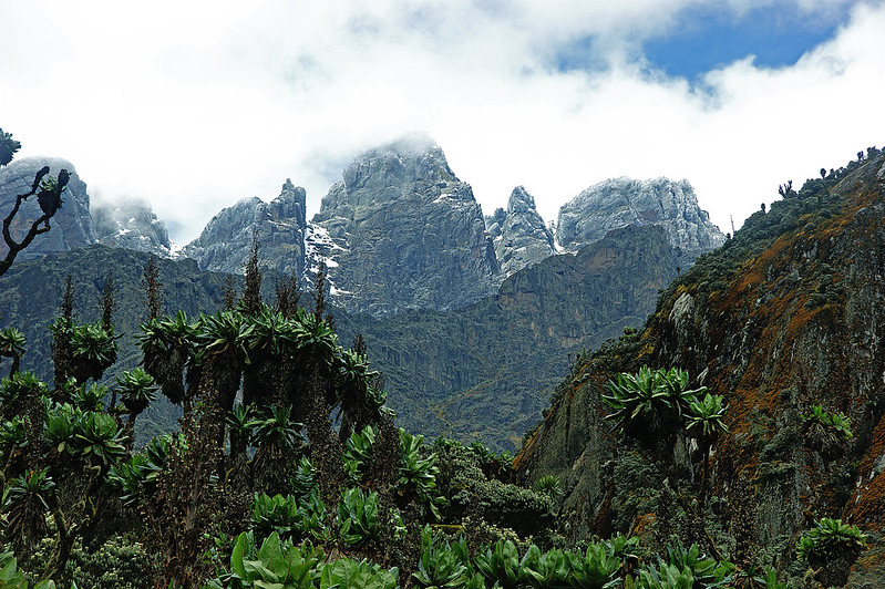
The Portal Peaks become visible for the first time on Day 2, appearing above the forest line in the early morning as the trail descends briefly from Nyabitaba to the Mubuku River and the Kurt Shafer Bridge.
Named for a pioneering Rwenzori mountaineer, the bridge spans the confluence of the Mubuku and Bujuku rivers in a position of considerable natural drama. From the bridge, and more clearly from the trail above it, the Portal Peaks’ twin rocky spires are identifiable against the sky above the forest, close enough to suggest proximity and far enough in altitude to maintain their authority as a three-day objective.
The bamboo zone above the bridge is the Central Circuit’s most physically demanding vegetational section. The culms rise high, the trail narrows, and the gradient is sustained and muddy in all seasons. Trekking poles earn their place on the equipment list here. The bamboo gives way to Hagenia-Hypericum woodland at around 3,000 meters, and the transition is both visual and atmospheric: the enclosed green tunnel of the bamboo opening into the broader, more light-filled woodland where the moss-draped Hagenia trees carry their extraordinary epiphytic burden and the yellow of the Hypericum flowers appears in every clearing.
John Matte Hut, at 3,414 meters, sits at the edge of the Hagenia woodland with the Bigo Valley panorama ahead and the first giant lobelias beginning to appear on the upper slopes. The hut’s terrace is the program’s first genuinely panoramic viewpoint, and the Portal Peaks are visible from it above the valley in the late afternoon on clear days, their silhouettes now recognizable and distinctly closer than the previous morning’s first sighting. Tomorrow, we will explore the Bigo Bog and fully enter the afro-alpine moorland.
Day 3: The Bog and the Giants — John Matte to Bujuku Hut
Elevation: 3,414m → 3,9 m | Altitude Change: +5 m | Distance: ~7 km | Trekking Time: 4–5 hours
The Bigo Bog deserves its reputation. It occupies the wide, flat valley bottom below John Matte in a papyrus and sphagnum wetland that the Uganda Wildlife Authority has fitted with boardwalks through the most challenging sections. The boardwalks address the problem practically; they do not entirely solve it. The margins of the bog are wet and require the careful footwork that the mountain consistently demands. The Rwenzori has been wet for longer than human civilization has existed, and the bog is its most direct expression of this reality.
What the boardwalk sections of the bog provide, alongside the mud management, is the program’s first extended view of the giant lobelia and groundsel zone in its full expression. On the higher margins of the Bigo Valley floor and increasingly from the midsection of the morning’s trekking, the Lobelia wollastonii plants erupt from the moorland in their dense architectural rosettes. The Dendrosenecio adnivalis groundsel stands as an individual monument, 5 to 6 meters tall. Walking through these botanical communities, in the Rwenzori’s particular combination of cold, moisture, and cloud, is the experience that has defined the mountain’s reputation in the natural history world since the first expeditions of the early twentieth century. For the first-time Rwenzori trekker, the Bigo Valley moorland is a revelation that no amount of prior reading adequately prepares you for.
Bujuku Hut, at 3,977 meters, sits above dark, cold Lake Bujuku with the Stanley, Speke, and Baker glaciated massifs visible above it in three different compass directions on clear afternoons. This is the program’s highest camp and the finest mountain panorama available on the Central Circuit below the glacier zone. The Portal Peaks are visible from the hut area as a distinct rocky formation on the ridge to the east, now only a day’s trekking away. The cold at Bujuku is serious and must be respected in the sleeping bag selection.
Day 4: The Acclimatisation Day — Exploring the Bujuku Valley
Elevation: Base: 3,977m | Ascents to 4,100–4,200m | Altitude Change: Variable +200m optional | Distance: 4–8km depending on activity | Trekking Time: 3–5 active hours
The acclimatization day at Bujuku is the six-day program’s strategic investment in the safety and quality of the Day 5 Portal Peaks summit. At nearly 4,000 meters, the body is operating at approximately 60 percent of sea-level oxygen availability, and the additional 24 hours at this altitude allow the physiological adaptation process to advance before the morning ascent to 4,000 meters and above on the Portal Peaks approach. The acclimatization day also allows the group to explore the Bujuku Valley in the depth that the ascent days, moving through with forward momentum, do not permit.
Your private guide proposes a morning program calibrated to the group’s condition: typically a guided walk into the valley floor’s giant lobelia and groundsel communities, with a focus on the ecology and natural history of the Afro-alpine zone. The botanical diversity of the Bujuku Valley is extraordinary even by the standards of the Rwenzori’s already exceptional vegetation: the lobelias, the groundsels, the Alchemilla cushion plants, the sphagnum mosses, and the endemic invertebrate communities that depend on them represent an ecological system of remarkable complexity at nearly 4,000 meters. A morning spent in this valley with a knowledgeable guide transforms the trekking program from a physical challenge into a natural history experience of genuine depth.
The afternoon at Bujuku is free for rest, observation from the hut terrace, and the quiet contemplation that the mountain consistently rewards. The three glacier massifs above the camp, Stanley, Speke, and Baker, move in and out of view as the afternoon cloud builds and occasionally releases. Their glaciers, reduced by over 80 percent in the past century and predicted to be entirely gone before 2050, are visible at close enough range to register their scale and their fragility simultaneously. The evening briefing for the Portal Peaks summit day, conducted over dinner as the mountain settles into its early dark, covers the approach route, the altitude management strategy for reaching 4,000 meters, and the descent plan.
Day 5: The Portal Peaks Summit Day
Elevation: 3,977m → ~4,000m North Portal, ~3,998m South Portal → 3,414m (John Matte) | Altitude Change: +~200m gain / ~-763m descent | Distance: ~12km total | Trekking Time: 8–10 hours
The Portal Peaks summit day begins with the pre-dawn departure that the altitude demands for reliable morning conditions. The trail from Bujuku to the Portal Peaks departs at 06:00, moving through the giant lobelia moorland in the first light of the morning when the valley is at its most atmospheric: the mist from Lake Bujuku rises into the cold air, the lobelias are dark and still against the pale sky, and the first bird calls of the endemic species begin their territorial declarations in the heather above the camp.
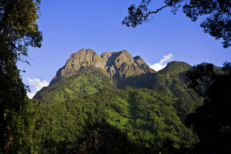
The Portal Peaks, North Portal at approximately 4,000 meters and South Portal at approximately 3,998 meters, are the twin spires that have been visible from the trail since Day 2, and reaching their base after four days of ascending approach gives the final climb a quality of earned completion. The approach from the Bujuku side involves rocky scrambling on the final approach to the summit ridge, where the trail requires careful footwork and, in places, the use of hands. There is no technical climbing involved; these are not the glacier routes of the higher peaks, but the scramble section rewards the careful and penalizes the careless. Your private guide leads the route with the unhurried assurance of someone who has taken many groups to this specific summit and knows every foothold.
From the summit of the Portal Peaks, the view encompasses the full Rwenzori central massif in its most concentrated and dramatic expression. Mount Stanley’s glacier system is above and directly to the west, its Margherita and Alexandra peaks visible on clear mornings as the program’s higher objective for a future return. Mount Speke’s Vittorio Emanuele Glacier addresses the northwestern skyline. The Bujuku Valley and its dark lake lie below, surrounded by the giant lobelia moorland that the preceding days have made familiar. And to the east, Uganda’s Albertine Rift Valley extends in its broad, lake-dotted landscape to a horizon that seems to mark the edge of the world.
The descent from the Portal Peaks drops back through the Bujuku approach and continues down the Central Circuit corridor to John Matte Hut at 3,414 meters, positioning the group for the final full descent on Day 6. The afternoon at John Matte, at a comfortable altitude after four nights above 3,900 meters, has a quality of physical ease and emotional satisfaction that the preceding days have been preparing for.
Day 6: The Long Return — Descent to Nyakalengija and Kasese
Elevation: 3,414m → 1,646m | Altitude Change: ~-1,768m descent | Distance: ~17km | Trekking Time: 7–8 hours
The final day of the Portal Peaks program returns through the full Central Circuit trail descent corridor in a single long stage, the most physically demanding day on the legs and knees of any in the program. The Hagenia woodland, the bamboo, and the montane forest are traversed in reverse, and the descent through each vegetation zone has the quality of a landscape revisited: familiar in form and sound, different in the direction of approach and the emotional context of a completed mountain program.
The bamboo section on descent is the morning’s most demanding physical challenge, and the trekking poles that helped on the ascent are equally essential here. The forest below the bamboo receives the group with warmth and bird calls, and the sound of the Mubuku River below the trail becomes louder with each hour as the altitude decreases. The Nyabitaba ridge, where the program began five days ago, is a recognizable landmark in the mid-descent.
The Nyakalengija trailhead arrives in the mid-to-late afternoon, and the UWA exit registration marks the program’s formal completion. The summit certificates for the Portal Peaks, signed by your guide and bearing the park stamp, are the physical record of five days of mountain experience. The vehicle is waiting for the return drive to Kasese. Behind the vehicle, as it descends toward the town, the Rwenzori’s profile is visible above the foothills, cloud-wrapped and silent, the Portal Peaks somewhere within it, already part of a memory that will prove more durable than the aching legs of the descent.
What’s Included
The 6-Day Portal Peaks Trek via the Central Circuit is managed as a fully inclusive mountain program from your arrival in Kasese. Pre- and post-trek accommodation in Kasese on a bed and breakfast basis (Snow Height Lodge, Ruboni Community Camp, or similar based on preference), all five nights of mountain hut accommodation along the Central Circuit (Nyabitaba Hut, two nights at John Matte Hut, and two nights at Bujuku Hut), a private mountain guide throughout all six days, a personal porter carrying your main load of up to 15 kilograms, an armed Uganda Wildlife Authority ranger escort, all UWA park entrance and hut fees, all mountain meals from Day 1 dinner through Day 6 lunch prepared by the guide team, hot drinks at every camp, all private vehicle transfers between Kasese and the Nyakalengija trailhead, and a comprehensive pre-departure equipment and fitness guide are all included.
What’s Not Included
International flights, personal trekking equipment (waterproof hiking boots with ankle support, trekking poles, a sleeping bag rated to minus five degrees Celsius for Bujuku or minus ten for maximum comfort, a full waterproof layering system, waterproof gloves and a warm hat, gaiters, and a headtorch with spare batteries), personal medical items including altitude sickness medication, alcoholic beverages, personal snacks, gratuities for the guide and porter team, laundry, and travel insurance covering emergency evacuation are not included. Glacier equipment is not required. A detailed equipment sourcing guide is provided with booking confirmation.
Best Time to Trek the Portal Peaks via the Central Circuit
The Rwenzori Mountains receive precipitation year-round, and any visit to this range should be planned with the expectation of rain on at least some days regardless of season. The mountain creates its own weather systems, and the cloud and mist that frequently cover the upper sections are as much a part of the Rwenzori experience as the botanical spectacle and the mountain views. The Portal Peaks program is accessible year-round, and the mountain is beautiful in all conditions.
The primary trekking window of June through August provides the most reliable conditions. Trail conditions are at their most navigable, the Bigo Bog is most manageable, and the probability of clear views from the Portal Peaks summit toward the Stanley and Speke glacier massifs is at its annual peak. The acclimatization day at Bujuku in June and July often provides extended periods of afternoon clarity that allow the full panorama of the three glacier massifs to reveal themselves. Booking through Gorilla Safaris at least three to four months in advance for primary-season departures is recommended.
December through February is an excellent secondary window with good weather prospects and lower visitor numbers on the Central Circuit. Overnight temperatures at Bujuku are colder in this period than in the primary season, making a sleeping bag rated to minus ten degrees Celsius advisable even for a program that does not ascend into the glacier zone.
The wet seasons of March to May and September to November are fully viable for the Portal Peaks program and are preferred by birders and botanists who value the lush, vivid vegetation of the wet months. The Bigo Bog is at its most dramatic and most challenging in these periods. Views from the Portal Peaks are less reliable. For families and first-time trekkers, the June-August window is the recommended choice.
Fitness and Suitability
The 6-Day Portal Peaks Trek is classified as a moderate-to-strenuous mountain trekking program and is the most accessible multi-day Rwenzori program for trekkers without prior high-altitude experience. No glacier equipment or technical climbing skills are required. The program is suitable for fit adults and teenagers aged approximately 14 and above who have experience of multi-day walking and can manage sustained gradients over consecutive days.
A minimum of three months of regular aerobic exercise, including regular hillwalking or equivalent training, is recommended. The highest overnight altitude of 3,977 meters at Bujuku Hut can produce mild altitude effects such as headache, reduced appetite, and disturbed sleep that the acclimatization day on Day 4 is designed to address. Trekkers with prior altitude experience above 3,000 meters will find the program very manageable. Those approaching it as their first high-altitude experience should follow the preparation guidance in their pre-departure document carefully. Consultation with your physician before departure is advisable.
Frequently Asked Questions: 6-Day Portal Peaks Trek via Central Circuit
What are the Portal Peaks in the Rwenzori Mountains?
The Portal Peaks are two prominent rocky spires—North Portal at approximately 4,000 meters and South Portal at approximately 3,998 meters—that guard the eastern approach to the Bujuku Valley and the central glaciated massifs of the Rwenzori Mountains. They are among the most recognizable features of the Central Circuit approach corridor and are visible from multiple points on the trail from Day 2 onward. The Portal Peaks are the summit objective of the 6-day program and represent the highest point achievable on the Central Circuit without entering the glacier zone.
Do I need glacier equipment for the Portal Peaks trek?
No. The Portal Peaks at approximately 4,000 meters are reached via rocky mountain trekking terrain without glacier crossing. Crampons, an ice axe, and a rope are not required. Waterproof hiking boots with ankle support, trekking poles, and appropriate cold-weather layering for temperatures down to minus five degrees Celsius at Bujuku Hut are the essential equipment requirements. The 6-day Portal Peaks program is specifically designed for trekkers without glacier equipment or technical mountaineering experience.
Is the Portal Peaks trek suitable for beginners?
Yes. The 6-day Portal Peaks program is the most accessible multi-day Rwenzori program for trekkers without prior high-altitude experience. It is suitable for fit adults and teenagers aged approximately 14 and above. The highest overnight altitude of 3,977 meters at Bujuku Hut is below the altitude where serious altitude sickness typically occurs, and the program’s acclimatization day on Day 4 provides the body with appropriate preparation for the Day 5 summit approach. Regular aerobic fitness and prior multi-day walking experience are recommended, but high-altitude mountaineering experience is not required.
How high are the Portal Peaks?
North Portal Peak stands at approximately 4,000 meters above sea level and South Portal Peak at approximately 3,998 meters. Both summits are accessible from the Bujuku Hut area on the Central Circuit without glacier equipment. At 4,000 meters, the Portal Peaks sit well above the bamboo and forest zones and provide panoramic views of the Rwenzori’s central glacier massifs, Mount Stanley, Mount Speke, and Mount Baker—that are among the finest mountain panoramas available on any Rwenzori trekking program below the glacier zone.
What vegetation zones does the 6-day program pass through?
The program passes through four of the Rwenzori’s five vegetation zones. The montane rainforest of the lower approach (Day 1 and descent Day 6) is home to colobus monkeys, Rwenzori turacos, and the endemic three-horned chameleon. The bamboo zone above the Kurt Shafer Bridge provides the most physically challenging section of the lower mountain. The Hagenia-Hypericum woodland above the bamboo is a moss-draped, lichen-laden forest of extraordinary beauty. The Afro-alpine moorland of the Bigo Valley and Bujuku area provides the giant lobelia and Dendrosenecio groundsel botanical spectacle that defines the Rwenzori’s global identity. The program does not enter the fifth zone, the glacial high-alpine zone above 4,200 metres.
What is the Bigo Bog and how challenging is it?
The Bigo Bog is a papyrus and sphagnum wetland occupying the flat valley floor below John Matte Hut at approximately 3,400 to 3,500 meters. Boardwalks have been installed through the most challenging sections, but the bog margins require careful footwork and acceptance of wet conditions. In the wet seasons the boardwalk edges may be submerged. In the dry seasons, the bog is more manageable, but it still demands attention. The Bigo Bog is a challenging section for most trekkers, but it is also the entry point to the giant lobelia and groundsel botanical zone, and the contrast between the difficulty of the terrain and the beauty of what surrounds it is one of the program’s most distinctive experiences.
How many huts are used on the 6-day Portal Peaks program?
The program uses three UWA mountain huts: Nyabitaba Hut at 2,652 meters (Day 1), John Matte Hut at 3,414 meters (Days 2 and 5 on the descent), and Bujuku Hut at 3,977 meters (Days 3 and 4). Each hut provides sleeping platforms, basic cooking facilities, and latrine blocks. Pre- and post-trek accommodation in Kasese is provided at Snow Height Lodge or Ruboni Community Camp.
Can the Portal Peaks trek be combined with gorilla trekking?
Yes. Kasese and the Rwenzori Mountains are approximately four to five hours by road from Bwindi Impenetrable Forest for gorilla trekking. A popular combination adds two gorilla trekking days at Bwindi to the six-day Portal Peaks program for a nine-day western Uganda program. Queen Elizabeth National Park also sits conveniently between Kasese and Bwindi.
What is the best time to trek the Portal Peaks?
June through August is the primary recommended window, offering the most reliable trail conditions, the most manageable Bigo Bog, and the highest probability of clear summit views from the Portal Peaks toward the glacier massifs. December through February is the secondary window with good conditions and lower visitor numbers. The program operates year-round, and it directs first-time trekkers toward the June–August primary window.
What is the view from the summit of the Portal Peaks trek like?
On a clear morning from the Portal Peaks at approximately 4,000 meters, the view encompasses Mount Stanley’s glaciated massif directly to the west, with the Margherita and Alexandra peaks visible at the range’s highest point. Mount Speke’s Vittorio Emanuele Glacier addresses the northwestern skyline. Mount Baker’s southern face is visible to the south. The Bujuku Valley and its dark lake lie below, surrounded by the giant lobelia moorland. Uganda’s Albertine Rift Valley extends to the east. This is among the finest mountain panoramas achievable on the Central Circuit without glacier equipment.