 The Rwenzori Mountain’s most distinctive characteristic — the quality that makes it unlike any other mountain in Africa and, frankly, unlike any other mountain in the world — is the progression of its Vegetation zones like:Montane Forest Zone (1,800–2,500 m), Bamboo and Mimulopsis Zone (2,500–3,000 m), Heather and Rapanea Zone (3,000–4,000 m), Afroalpine Moorland Zone (4,000–4,500 m), Nival Zone — Rock, Ice, and Glacier (above 4,500 m). As altitude increases, the vegetation transforms with strangeness that challenges every prior conception of what a mountain landscape should look like. These five Vegegtation Zones of Rwenzori Mountains National Park are not merely ecological categories; they are immersive environments, each with its own light, its own smell, its own acoustic character.
Montane Forest Zone (1,800–2,500 m)
The lower slopes are covered in rich montane rainforest — dense, layered, and full of life. Giant fig trees and Podocarpus pines dominate, festooned with epiphytic mosses and ferns. African olive trees, Rapanea, and Olea capensis form an understorey beneath the canopy. Colobus monkeys move through the upper branches; the chirruping of Albertine Rift endemic birds fills the spaces between the trees. The air is warm and heavy, the light filtered through layers of leaf to a green-gold dimness. This is the forest of approach — beautiful, energising, and unmistakably alive.
Bamboo and Mimulopsis Zone (2,500–3,000 m)
Above the montane forest, bamboo takes over — tall, dense, and luminous in the morning light. The Mimulopsis thickets that grow alongside the bamboo produce extraordinary purple flower blooms approximately every seven years, transforming the hillsides with an intensity of colour that is almost hallucinogenic. Chimpanzees and elephants occasionally move through this zone, though sightings are rarer here than in the forest below.
Heather and Rapanea Zone (3,000–4,000 m)
The transition from bamboo to heather is one of the most atmospheric moments of any Rwenzori trek. The trees grow smaller and stranger, their trunks and branches wrapped in thick mosses that make them look ancient and sculptural. The heathers — Erica arborea and related species — grow to fifteen metres in height here, forming a cathedral of gnarled branches through which the light filters in shafts. The air cools noticeably, the humidity increases, and the sound of the forest changes: quieter, more intimate, more aware of the altitude.
Afroalpine Moorland Zone (4,000–4,500 m)
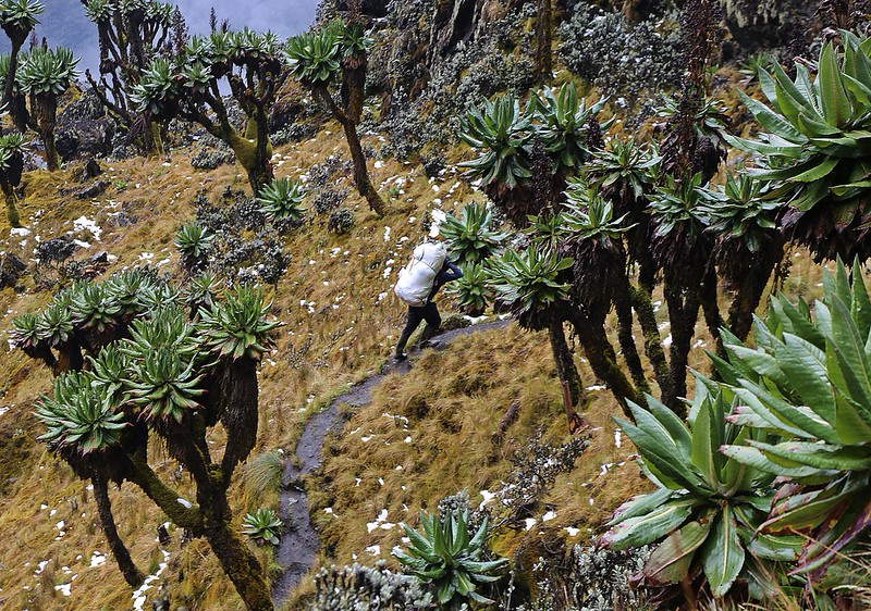
This is the zone that makes the Rwenzori famous. Above 4,000 metres, the heather woodland gives way to an open moorland of extraordinary botanical spectacle. Giant groundsels — Dendrosenecio species — stand five metres tall, their cabbage-like crowns of leaves silhouetted against a sky that is often silver with mist. Giant lobelias — Lobelia wollastonii — rise from the ground in towers of rosette leaves, their flowering stalks sometimes reaching six metres. Everlasting flowers — Helichrysum species, yellow and papery and impossibly cheerful — carpet the ground between the moss-covered rocks. The landscape is alien and magnificent and deeply, unexpectedly moving.
Nival Zone — Rock, Ice, and Glacier (above 4,500 m)
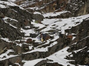 Above 4,500 metres, snow and glacier complete the transformation. The rock is bare, dark, and ancient — gneiss and granite that has been here for hundreds of millions of years. The glaciers — shrinking but still real, still visually extraordinary — drape the upper slopes of Mounts Stanley, Speke, and Baker in blue-white ice. The sky at this altitude is a different sky from the one below: clearer, harder, and on the right morning, a blue so deep it appears almost purple. The silence is absolute. The reward for reaching it is a view across the Rwenzori, across the DRC lowlands to the west, and on the clearest days, across the entire expanse of central African wilderness, that justifies every step of the climb.
Central Circuit Trail Of Rwenzori Mountains
The Central Circuit trail route Of Rwenzori Mountains is the most established and most comprehensive trekking route in the Rwenzori Mountains National Park. Beginning at the Rwenzori Mountaineering Services (RMS) headquarters near Nyakalengija, approximately 22 kilometers from Kasese on the mountain’s eastern approach, the circuit typically takes between seven and twelve days to complete depending on whether the summit of Margherita Peak is the objective.
The Central circuit trail route begins with a descent into the Mubuku River valley before climbing steeply through montane forest to Nyabitaba hut at 2,651 meters — the first overnight on the mountain and the gateway to everything above. From Nyabitaba, the trail follows the Mubuku River valley through increasingly spectacular scenery, passing Nyamilejju Camp at 3,048 meters and ascending to Bigo Hut at 3,400 metres, where the valley opens into a boggy plateau of extraordinary beauty — a landscape of moss-covered boulders, clear streams, and the first giant groundsels emerging from the mist.
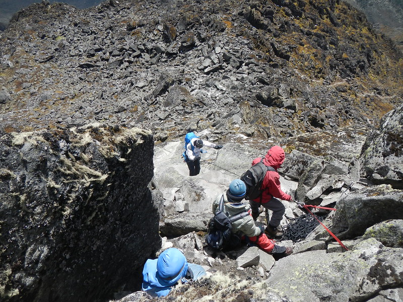
The circuit continues to Bujuku Hut at 3,962 meters, set in the bowl of the Bujuku Valley below the glaciated flanks of Mounts Stanley, Speke, and Baker. This is the mountain’s emotional centre — the point at which the full scale of the Rwenzori Mountains reveals itself and the trekker understands, in the most immediate possible way, exactly where they are. From Bujuku, the route to Margherita involves an ascent to Elena Hut at 4,541 meters — the highest overnight point on the standard circuit — and then a technical summit attempt via the Stanley Glacier, requiring crampons, ice axe, and a qualified mountain guide.
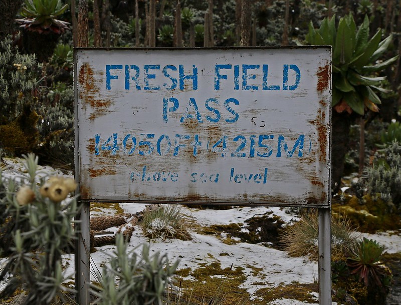
For trekkers not summiting, the Central circuit trail route of Rwenzori mountains continues from Bujuku over Freshfield Pass (4,282 m) — one of the route’s great moments of visual revelation, with panoramic views across the southern Rwenzori — and descends via Kitandara Lakes to Guy Yeoman Hut and out via the Mubuku valley. The Kitandara Lakes, set in a glacially carved bowl at 4,023 metres with Mounts Baker and Luigi di Savoia rising on either side, are among the most beautiful high-altitude lakes in East Africa.
The Kilembe Trail: The Adventure Route
The Kilembe Trail route of Rwenzori Mountains is a newer, more challenging, and in many ways more adventurous alternative to the Central Circuit. Beginning at the old copper mining town of Kilembe Trail Route, south of Kasese, the trail approaches the mountain from the south and offers a different suite of botanical and topographic experiences — deeper river valleys, steeper ridges, and a more sustained sense of genuine remoteness.
 The Kilembe Trail Route of Rwenzori Mountains in Rwenzori Mountains National Park passes through the southern peaks of Mount Emin, Mount Gessi, and Mount Luigi di Savoia — before connecting with the Central Circuit trail route at the Kitandara Lakes and continuing, if the summit is the objective, to Elena Hut and Margherita Peak. The trail typically takes 8 to 12 days for a full traverse or summit attempt. The huts on the Kilembe Trail route are more recently built than those on the Central Circuit and are in excellent condition, each positioned at natural stopping points with access to water and, on clear evenings, views that make the day’s effort feel immediately worthwhile.
The Kilembe Trail route of Rwenzori Mountains is increasingly popular with trekkers who have already completed the Central Circuit trail route and want a different perspective on the mountain, and with those whose primary objective is the distinctive southern peaks rather than Margherita peak of Rwenzori Mountains. Gorilla Safaris can design customized routes combining sections of both trails for trekkers with specific peak objectives or particular botanical interests.
Short Treks and Day Hikes
For travelers combining a Rwenzori visit with other Uganda Safaris — gorilla trekking in Bwindi Impenetrable National Park, chimpanzees in Kibale Forest National Park, game drives in Queen Elizabeth National Park — shorter Rwenzori trekking Expeditions offer a genuine taste of the mountain’s character without committing to a multi-day high-altitude expedition. A 1-day Rwenzori hike to Nyabitaba camp and back offers a full immersion in the montane forest zone and the first of the mountain’s remarkable Rwenzori trekking vegetation Zones. A two-day hike to Lake Mahoma — a beautiful crater lake set in the forest zone at approximately 2,960 metres — is one of the finest short mountain walks in Uganda, combining excellent birding with a rewarding overnight experience in a hut beside the lake.
By Road from Entebbe or Kampala
The drive from Entebbe International Airport to Kasese — the gateway town for Rwenzori Mountains National Park — covers approximately 380 kilometers and takes between 5 to 6 hours by private vehicle on Uganda’s western highway. The route passes through Kampala, then follows the Kampala–Fort Portal highway through Mubende and the tea estates of the Kibale foothills before descending into Kasese and the broad plain at the mountain’s base.
Gorilla Safaris provides private, air-conditioned safari vehicles with experienced driver-guides for all transfers, and the journey itself — passing through some of the richest agricultural and forested landscapes in Uganda — is a genuine pleasure rather than dead time.
Via Fort Portal: The Scenic Route
The most rewarding road approach to Rwenzori Mountains National Park passes through Fort Portal, the charming highland town that serves as the gateway to both Kibale Forest National Park and the Rwenzori Mountains National Park. Travellers combining Kibale chimpanzee trekking with a Rwenzori trekking expedition frequently use Fort Portal as a base for both, reducing overall road time and allowing a more relaxed pace of travel. The 45-kilometre drive from Fort Portal to Kasese follows the Rwenzori mountains’ northern flank with views of the range’s Portal Peaks appearing through the plantation forest and tea estates.
By Light Aircraft
Charter flights from Entebbe to Kasese airstrip reduce the road journey to approximately one hour of flying time. Gorilla Safaris arranges charter aircraft as part of multi-destination Uganda safaris, and the flight itself — crossing the western Rift Valley with the Rwenzori range filling the horizon ahead — offers an aerial perspective on the mountain’s scale and topography that no road journey can provide.
| Route | Approximate Time |
| Entebbe/Kampala → Kasese (road) | 5–6 hours by private vehicle |
| Fort Portal → Kasese (road) | 45–60 minutes by private vehicle |
| Entebbe → Kasese (charter flight) | ~1 hour flying |
| Queen Elizabeth NP → Kasese | ~1 hour by road |
| Kibale Forest → Kasese (via Fort Portal) | ~2 hours by road |
The Rwenzori Mountains, famously, wet mountains, generates its own weather system — the moist air rising off the Congo Basin collides with the high massif and produces rainfall of exceptional regularity and volume. Understanding the seasonal pattern is essential for planning a Rwenzori trekking expedition, though it is equally important to understand that the mountain’s legendary cloud cover is present to some degree in every month of the year.
Best Time: June to August and December to February
 The two dry seasons — June through August and December through February — are the recommended windows for Rwenzori trekking in Rwenzori Mountains National Park. During these months, rainfall is reduced (though never absent), cloud cover lifts more frequently, and the trails are at their most manageable. The summit of Margherita Peak is most consistently achievable during the dry season months, and the probability of at least partial summit views is significantly higher. July and August represent the absolute peak of the dry season and are the most popular months for most Rwenzori Mountains Trekking Expeditions
December through February offers a slightly quieter experience with similarly good conditions. The Christmas and New Year period is busy at the park entry points, but the mountain itself has a remarkable capacity to absorb visitor numbers without losing its atmosphere of solitude.
Shoulder Seasons: September, March
The transitional months of September and March offer conditions that are unpredictable but often rewarding. Rain is possible at any time, but so are periods of extraordinary clarity — mornings when the cloud lifts from the upper massif to reveal the glaciers in full sunlight, with views across the DRC lowlands that are simply unavailable in the murkier heart of the rainy season. Experienced Rwenzori trekkers sometimes prefer the shoulder months for their combination of reasonable conditions and significantly reduced visitor numbers.
Wet Season: April to May and October to November
The long rains of April and May and the short rains of October and November bring Rwenzori mountains trekking to its most challenging state. Trails become extremely muddy — the Rwenzori mountains’ characteristic boggy terrain is demanding enough in dry conditions; in wet season, it requires significant additional physical effort. River crossings become more challenging, and the frequency of cloud cover means that summit views are rare. For experienced trekkers who specifically seek the Rwenzori Mountains most atmospheric and otherworldly conditions — the fog thick in the heather zone, the giant lobelias emerging from the mist like prehistoric sentinels — the wet season has its own dark, dramatic beauty. Gorilla Safaris can advise on wet-season trekking for clients who want the mountain at its most primordial.
Period | Conditions | Recommendation |
June–August | Best dry season, clearest views | Highly recommended; book early |
December–February | Second dry season, excellent | Recommended; good availability |
September & March | Transitional, variable | Good for experienced trekkers |
April–May | Long rains, challenging terrain | Difficult; not recommended for first-timers |
October–November | Short rains, muddy trails | Challenging; dramatic atmosphere |
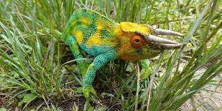
Wildlife in Rwenzori Mountains National Park
The Rwenzori Mountains’ mammal populations are not its primary draw in the way that the gorillas of Bwindi Impenetrable National Park or the elephants of Queen Elizabeth National Park are — but they are present, they are diverse, and they surprise. Chimpanzees are occasionally encountered in the lower forest zones, particularly in the morning hours before the forest heats. African forest elephants move through the bamboo zone, their presence announced more often by broken vegetation and fresh tracks than by direct sighting. Hyraxes — small, rabbit-like mammals that are, improbably, the closest living relatives of the elephant — populate the rocky outcrops of the upper moorland and are frequently heard before they are seen: a loud, descending scream from a boulder that turns out to contain a creature the size of a rabbit.
The Rwenzori leopard has been recorded in the park, though sightings are genuinely rare. African golden cats, servals, and a variety of mongoose species complete the predator roster. The Rwenzori black-fronted duiker, a forest antelope endemic to the Albertine Rift, is one of the park’s more reliably seen mammals on the lower trails.
Birds
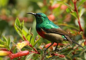
With 217 recorded species, including 19 Albertine Rift endemics, the Rwenzori is one of the finest birding destinations in Uganda and, by extension, in Africa. The Rwenzori turaco — a brilliantly coloured bird endemic to this mountain system — is the most sought-after target species, its crimson wing patches catching the light as it moves through the heather canopy. The handsome francolin, the strange-tailed (or Rwenzori) batis, the cinnamon-chested bee-eater, and the African green broadbill are among the other Albertine endemics that experienced birders target specifically on Rwenzori visits. The Nyombi swamp on the park’s lower margins offers additional wetland species including the African finfoot and the giant kingfisher.
Vegetation and Botanical Wonders
 The giant lobelia, giant groundsel, and tree heather of the Rwenzori’s afroalpine zone are this mountain’s signature attraction — the botanical spectacle that no other mountain in Africa, or arguably in the world, replicates. The giant Lobelia wollastonii, with its tower of rosette leaves and dramatic flowering stalk, is one of the most extraordinary plants in existence; standing beside one at 4,200 metres, with mist moving through the moorland and the sound of the wind in the groundsels, is an experience that belongs firmly in the category of things that must be seen to be understood.
The Bakonzo People and Cultural Heritage
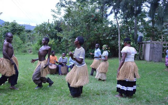 The Bakonzo people have lived on the slopes of the Rwenzori Mountains for centuries, and their relationship with the mountain — its forests, its rivers, its agricultural lower slopes — is the oldest and most complete understanding of this landscape that exists. Ruboni village, at the foot of the Central Circuit trail approach, offers an excellent cultural encounter with the Bakonzo community: guided homestead visits, traditional music and dance performances, craft demonstrations, and a walking tour that introduces the medicinal plants and agricultural systems of the mountain’s foothills. The income generated by these cultural tourism activities flows directly to the community and represents one of the park’s most meaningful conservation-linked livelihood programs.
Multi-Day Trekking and Mountaineering
The central activity of any Rwenzori visit — the reason the park was created and the reason serious travellers come here specifically rather than passing through — is the trek. Whether the objective is the full Central Circuit, the Kilembe Trail, a Margherita summit attempt, or a shorter forest excursion, the act of walking through the Rwenzori’s botanical zones over multiple days is the most complete and satisfying way to experience the mountain’s character. Gorilla Safaris designs and arranges Rwenzori treks of every length and difficulty level, from one-day forest introductions to twelve-day summit expeditions.
Bird Watching
 The Rwenzori is a dedicated birder’s objective in its own right. Guides from the local Bakonzo community who have trained specifically in bird identification accompany all trekking groups and are available for dedicated birding excursions in the park’s lower zones. The combination of montane forest, bamboo zone, and heather woodland within a single day’s walking distance of the park gate produces species lists that consistently surprise even experienced Uganda birders.
Cultural Walks and Ruboni Village Experience
The Ruboni Community Camp cultural program offers a half-day or full-day introduction to the Bakonzo way of life, led by community members who are both knowledgeable and deeply hospitable. The walks include visits to traditional homesteads, demonstrations of Bakonzo agricultural practice and food preparation, and an introduction to the community’s relationship with the mountain’s forest resources. The cultural walk pairs naturally with a Rwenzori trek as a way of grounding the mountain experience in its human context.
Nature Walks and Waterfall Hikes
For visitors who are not undertaking a full mountain trek, guided nature walks in the Rwenzori foothills and along the mountain’s river systems offer a genuine and rewarding taste of the park’s lower elevation ecology. The river valleys draining the mountain’s eastern slopes are spectacular — fast-moving water, hanging moss, and the sounds of the forest intensified by the acoustic quality of steep gorge walls. Several of the park’s waterfalls are accessible on day walks from Kasese or Ruboni village.
On the Mountain: Huts and Camps
The mountain itself is served by a series of huts managed by the Rwenzori Mountaineering Services. These huts — Nyabitaba (2,651 m), Nyamulejju (3,048 m), Bigo (3,400 m), Bujuku (3,962 m), Elena (4,541 m), Guy Yeoman (3,261 m), and Kitandara (4,023 m) on the Central Circuit trail, with equivalent facilities on the Kilembe Trail — are simple but functional mountain shelters equipped with sleeping platforms, cooking facilities, and toilets. The huts are clean, well-maintained, and part of what makes a Rwenzori trek logistically straightforward compared with many other African mountain ranges. Gorilla Safaris includes all hut accommodation in its trekking packages.
Luxury: Saad Hotel, Kasese
The finest accommodation in Kasese town, Saad Hotel offers comfortable, well-appointed rooms with reliable service and a restaurant that caters well to trekkers preparing for or recovering from the mountain. The hotel is the preferred pre- and post-trek base for Gorilla Safaris’ premium itineraries, and its central Kasese location makes it convenient for the drive to the mountain’s entry points.
Mid-Range: Ruboni Community Camp
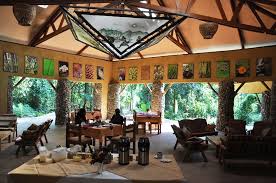
Set directly at the base of the Central Circuit trail approach, Ruboni Community Camp is the most atmospherically positioned accommodation in the Rwenzori’s foothills. The camp is managed by the local Bakonzo community, with bandas (self-contained cottages) set in gardens that look directly up at the mountain’s lower slopes. Waking at Ruboni on a clear morning and seeing the forested ridges of the Rwenzori rising above the camp is one of those unforced travel experiences that stays. The camp’s cultural program, food, and guiding services are outstanding, and staying here rather than in Kasese is consistently recommended by Gorilla Safaris guides for travelers who want the fullest possible connection with the mountain environment.
Mid-Range: Equator Snow Lodge
 Equator Snow Lodge is a comfortable, well-run property on the outskirts of Kasese that offers clean accommodation, reliable meals, and excellent guiding connections. The lodge is popular with both trekkers and general Uganda safari visitors who are passing through the Kasese area en route to Queen Elizabeth National Park.
Budget: Mountains of the Moon Hotel, Fort Portal
For travelers combining the Rwenzori with the broader Fort Portal area — Kibale Forest National Park, the Tooro Kingdom cultural sites, and the crater lakes — Mountains of the Moon Hotel in Fort Portal offers the best budget-to-quality ratio in the region. The hotel is clean, well-staffed, and excellently positioned for early morning departures toward both Kibale and Kasese.
The Rwenzori demands more specialized preparation than most Uganda safari activities. The combination of high altitude, persistent moisture, and technical terrain means that your gear list is not optional — it is the difference between a rewarding, safe, and comfortable expedition and a genuinely difficult one. These are the essentials our guides insist on.
Clothing and Layers
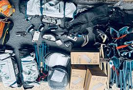 The layering system is the Rwenzori trekker’s most important packing principle. A moisture-wicking base layer against the skin, an insulating mid-layer (fleece or down), and a fully waterproof outer shell are the three components around which everything else is built. Temperatures range from tropical at the park gate to sub-zero at Elena Hut and on the glacier, and the transition between these extremes can happen within a single day of climbing. Waterproof trousers are essential — the Rwenzori’s trail mud is legendary, and no amount of rain cover from above manages the problem of walking through knee-deep bog. Wool or synthetic hiking socks in at least three pairs — the mountain’s moisture means that socks need to be changed frequently to prevent blisters.
Footwear
Waterproof, ankle-support hiking boots are mandatory for any Rwenzori trek above the forest zone. The boots must be well broken-in before departure — blisters are the most common reason for early descent from the mountain, and they are almost always the result of new footwear. For the Margherita summit, crampons are required and are provided by Rwenzori Mountaineering Services as part of the summit package. Gaiters are strongly recommended for all trekkers — the Rwenzori’s boggy trail sections will defeat even the finest waterproof boots without them.
Equipment
A well-fitting 50–65 litre trekking pack carries your personal gear. Porters carry the heavier communal supplies, but each trekker is responsible for their own day-hiking essentials: water (at least two litres per day, with purification tablets as backup), high-energy snacks, a headlamp with spare batteries, trekking poles (essential on the Rwenzori’s uneven and often very steep terrain), sunscreen, and a personal first-aid kit including blister care, anti-inflammatory medication, and any personal prescriptions.
For summit attempts: crampons and an ice axe are provided by RMS. A helmet is recommended for the glacier section. Altitude sickness medication — discuss with your physician before departure. A sleeping bag rated to −15°C for Elena Hut nights. High-factor UV protection at altitude — the sun above 4,000 metres is considerably more powerful than at sea level, even on an overcast day.